If you’ve ever watched the 7-day forecast for Flagstaff change three times in two days, you already understand why this site exists.
Models like GFS, ECMWF, ICON, and the NBM are genuinely good tools — but run them over Arizona’s sky island terrain, where elevation swings thousands of feet over a few miles, and their agreement falls apart fast. Add in how loosely terms like El Niño, La Niña, and “the PDO is positive” get used in public forecast talk, and you get a lot of confident-sounding noise.
This site tracks the models against reality (ongoing QPF comparisons across GFS/IFS/NBM/ICON versus actual observations around Flagstaff and Anthem), takes teleconnections seriously rather than seriously-sounding (the Flagstaff Seasonal Outlook tool, built on McCabe, Palecki & Betancourt’s 2004 PNAS research, reports historical analog tendencies — not deterministic forecasts), and keeps an eye on the MJO, which matters more for monsoon timing and winter storm tracks here than most people realize.
The goal throughout: stay grounded in what the data shows, uncertainty included.
A few beliefs I haven’t tested yet
Tuesday afternoon forecasts verify better. I have no data on this, just a hunch — and I don’t think the models themselves are the reason, since nothing in the physics cares what day it is. My guess is it’s upstream: model input data still gets human quality control (catching bad sensors, flagging bad soundings), and that QC staffing likely thins out over weekends. If noisier data creeps into Saturday/Sunday’s cycles, Tuesday afternoon is about where you’d expect the backlog to have cleared. Pure speculation for now — but easy to check once there’s enough verification history, so consider it an open question.
“El Niño winters are always wet” is too flat. Not every El Niño behaves the same way here, and Niño 3.4 isn’t the only dial on the board — Atlantic Ocean temperatures (AMO) matter as much or more at the multidecadal scale, per McCabe et al. That’s why the outlook tool doesn’t stop at ENSO phase alone.
Monsoon ≠ one storm, and not every dust storm is a haboob. The monsoon is a seasonal wind/moisture pattern, not an event — calling one afternoon storm “the monsoon” is like calling one cold front “winter.” And “haboob,” a real term for a specific outflow-driven dust storm, has become the catch-all label for any dust blowing through — most events here aren’t that.
What “the models don’t agree” actually looks like
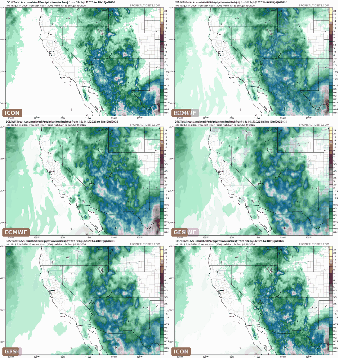
Here’s this week’s example: ICON, ECMWF, and GFS 5-day accumulated precipitation forecasts for the Southwest, all initialized Tuesday afternoon, all valid for the same period. Same atmosphere, three different stories about where the rain falls.
More soon — starting with a look at how this past week’s forecasts actually verified.