
CAPE is a measure, in joules per kilogram (J/kg), of the energy available to a rising air parcel once it becomes positively buoyant relative to its surroundings. It is the primary thermodynamic index used to estimate how strong thunderstorm updrafts could become on a given day. Forecasters treat it as a standard input to every convective and severe-weather outlook.
Definition
In plain terms: Picture a bubble of warm, humid air near the ground on a hot day. Meteorologists call this bubble a parcel. A parcel is a useful stand-in for a small “blob” of air that can be tracked as it moves, assumed not to mix with the air around it. Warm air is lighter than the cooler air surrounding it. So once the parcel breaks free, it starts rising on its own, much like a hot air balloon or a beach ball let go underwater.
As the parcel rises into thinner air higher up, it expands, and that expansion cools it. It isn’t losing heat to anything around it. The cooling comes purely from expanding. (You can feel the same effect when air rushes out of a tire valve and feels cold, or when a bike pump warms up as you compress air into it.) Meteorologists call this kind of temperature change adiabatic: it happens purely from expansion or compression, with no heat gained or lost to the surroundings. They assume a rising parcel behaves this way so they can calculate how its temperature changes with height.
As long as the rising parcel stays warmer than the air around it, it keeps accelerating upward, picking up energy the whole way. CAPE is simply a measure of how much energy a parcel can gain this way. It stops accelerating once it cools back down to match its surroundings. The more CAPE there is, the more forceful a thunderstorm’s updraft can be. Think of it as fuel in the tank for a storm.
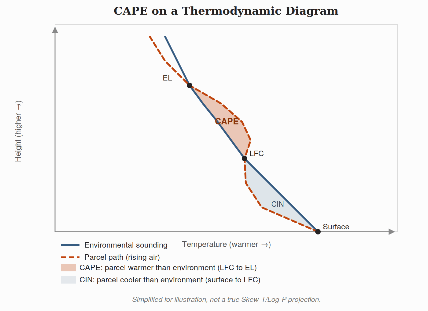
In formal terms: CAPE is the vertical integral of buoyancy between two heights on a sounding. The lower bound is the level of free convection (LFC), where a lifted parcel first becomes warmer than the surrounding air. The upper bound is the level of neutral buoyancy (LNB), also called the equilibrium level (EL), where the parcel cools back down to match the environment:
CAPE = ∫ (from z_LFC to z_LNB) g · (T_vp − T_ve) / T_ve · dz
- g: gravitational acceleration
- T_vp: virtual temperature of the lifted parcel
- T_ve: virtual temperature of the environment
- z: height
Virtual temperature (T_v) is a kind of adjusted temperature. It’s the temperature dry air would need to have to match the density of the actual, moist air at the same pressure. Moist air is less dense than dry air at the same temperature. So virtual temperature is always a little higher than the true temperature whenever water vapor is present. Virtual temperature is used instead of plain temperature because it also accounts for the extra buoyancy contributed by water vapor. On a thermodynamic (Skew-T/Log-P) diagram, meteorologists see CAPE directly as the “positive area.” It’s the area enclosed between the parcel’s lifted path and the environmental sounding, from the LFC up to the EL. The bigger the shaded area, the more energy is available.
Units and Typical Values
CAPE is expressed in J/kg. As a rough operational guide for surface-based CAPE (SBCAPE):
- < 1,000 J/kg: marginal instability; ordinary or weak convection more likely than severe storms
- 1,000–2,500 J/kg: moderate instability; a common range for organized thunderstorms
- 2,500–4,000 J/kg: strong instability, often associated with severe storm potential
- > 4,000–5,000 J/kg: extreme instability, though this alone does not guarantee severe weather
The National Weather Service is explicit that there is no single CAPE threshold above which severe weather becomes certain. CAPE describes available energy, not whether or how that energy will be released (see Relationship to CIN below).
Forecasters also compare several CAPE variants, since which parcel is used can change the result significantly:
- SBCAPE: surface-based
- MLCAPE: mixed-layer, using the mean of the lowest ~100 mb
- MUCAPE: most-unstable, using the most favorable parcel in the lowest levels
Physical Interpretation and Forecasting Significance
CAPE sets a rough ceiling on how much kinetic energy a parcel could gain during its ascent. That gives a crude estimate of the fastest an updraft could theoretically move:
w_max ≈ √(2 · CAPE)
In practice, entrainment of drier environmental air, water loading, and mixing all reduce updraft speeds well below this theoretical maximum. Even so, CAPE correlates strongly with observed updraft intensity. Forecasters use it alongside wind shear, moisture, and lift to assess severe-weather and hail potential. High CAPE combined with strong deep-layer shear is a classic signature for organized, potentially severe convection, including supercells.
Relationship to CIN
CAPE measures how much energy is available once convection begins, but it says nothing about whether convection will begin. That depends on Convective Inhibition (CIN): the energy barrier that a parcel must overcome to reach its LFC in the first place. That barrier is often a warm layer, or “cap.” A day with very large CAPE and a strong cap can go all afternoon without a storm. Then it can erupt once the cap finally erodes, or is broken by a lifting mechanism.
Relevance to the Sky Islands
In Arizona’s sky island ranges, CAPE typically builds through the morning and early afternoon as solar heating destabilizes the boundary layer. This is especially pronounced during the North American monsoon (roughly July–September), when low-level moisture from the Gulf of California and Gulf of Mexico is in place.
CAPE by itself doesn’t initiate storms, so the higher terrain plays an outsized role. Elevated peaks and ridgelines heat and destabilize faster than the surrounding desert floor. That makes them far more effective at eroding any capping inversion (see CIN). That’s why monsoon convection so often fires first over the sky islands themselves. It then drifts, or spreads via outflow, to the lower valleys later in the day.
See Also
- Convective Inhibition (CIN)
- Level of Free Convection (LFC)
- Lifting Condensation Level (LCL)
- Level of Neutral Buoyancy / Equilibrium Level (EL)
- Skew-T/Log-P diagram