
CIN (also written CINH) is a measure, in joules per kilogram (J/kg), of the energy an air parcel must expend to overcome a stable layer in the atmosphere before it can rise freely. That stable layer is sometimes called a “cap.” Where CAPE (Convective Available Potential Energy) measures the energy available once convection starts, CIN measures the resistance that must be broken for convection to start at all.
Definition
In plain terms: Think of a pot of water on the stove with a heavy lid on it. As the water heats up, steam wants to rise and escape, but the lid holds it in. Pressure builds up underneath instead of being released right away.
In the atmosphere, meteorologists imagine tracking a small rising bubble of air called a parcel. As the parcel rises into thinner air, it expands, and that expansion cools it automatically. It isn’t losing heat to the air around it. The cooling comes purely from expanding. (You can feel the same effect when air rushes out of a tire valve and feels cold.) Meteorologists call this kind of temperature change adiabatic: it happens only from expansion or compression, with no heat exchanged with the surroundings.
Once the parcel has risen and cooled enough, its moisture starts condensing into a cloud. That condensation releases a small amount of heat, which slows the cooling slightly. Meteorologists call this later stage pseudoadiabatic.
Often, a layer of warmer air sits above the surface like a lid. The rising parcel is cooler than that layer and can’t push through it on its own. CIN measures how strong that lid is. It’s how much extra heating or physical lift, from the sun, a front, or a mountain range, is needed to remove it. The stronger the cap, the more it resists storms forming. But once enough heat or lift finally breaks it, the energy that built up underneath can release all at once. It’s like the lid blowing off a pressure cooker.
In formal terms: CIN totals up the negative buoyancy a parcel works against along its full ascent to the point where it can finally rise on its own. That path runs adiabatically from the parcel’s starting level up to the lifting condensation level (LCL). From there it continues pseudoadiabatically, from the LCL to the level of free convection (LFC), through any layer where the parcel is colder than its surroundings:
CIN = −∫ (from p_i to p_f) R_d · (T_vp − T_ve) d(ln p)
- p_i: pressure at the parcel’s origin
- p_f: pressure at the LFC
- R_d: specific gas constant for dry air
- T_vp, T_ve: virtual temperatures of the parcel and environment
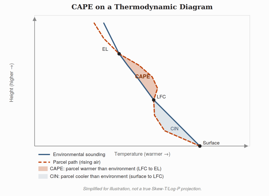
On a thermodynamic (Skew-T/Log-P) diagram, CIN appears as the “negative area” between the parcel path and the environmental sounding, below the LFC. It is the counterpart to the positive area that defines CAPE above it.
Units and Typical Values
CIN is expressed in J/kg, conventionally as a negative number (or as a positive “magnitude” figure, depending on the source). As a rough operational rule of thumb:
- ~0 to −25 J/kg: negligible to weak cap; little resistance to convective initiation
- −25 to −100 J/kg: moderate cap; some forcing (daytime heating, a front, orographic lift) usually needed to initiate storms
- more negative than −100 J/kg: strong cap; often suppresses convection entirely unless a substantial lifting mechanism is present
These figures are illustrative rather than fixed thresholds. How much CIN is “enough” to matter depends heavily on how much CAPE is present and what lifting mechanisms are available.
Physical Basis and Forecasting Significance
A cap most often forms from a layer of warm, sinking (subsident) air aloft, or from overnight cooling and stabilization near the surface. Its practical effect is to delay convective initiation. Heating, moistening, or mechanical lift must first erode the cap, or physically force parcels through it, before storms can form. That lift can come from fronts, outflow boundaries, drylines, or terrain.
CIN is not simply an obstacle to be avoided in every forecast. It is often meteorologically important precisely because it suppresses convection through the hottest, most unstable part of the day. That lets CAPE build to much larger values than it otherwise would. When the cap finally breaks, often in the late afternoon or evening, the accumulated instability can release rapidly. The result can be intense, sometimes severe convection that initiates with little additional warning. This large-CAPE/strong-CIN combination is a classic recipe for isolated but explosive storm development.
Relationship to CAPE
CAPE and CIN work as a pair on the same sounding. CAPE, above the LFC, describes how vigorous convection could be. CIN, below the LFC, describes how hard it is to get there. A day can have abundant CAPE and never produce a storm if CIN is too strong and no lifting mechanism arrives to erode it. See CAPE for the energy side of this relationship.
Relevance to the Sky Islands
Mornings in Arizona’s sky island region frequently begin with a capping inversion left over from overnight radiative cooling and large-scale subsidence. This inversion must be broken down before monsoon convection can develop.
Higher terrain heats and destabilizes faster than the surrounding desert valleys. So CIN typically erodes first over the peaks and ridgelines of the sky islands. That’s a major reason afternoon monsoon storms so often initiate over the higher terrain. They then spread to, or redevelop over, the lower valleys via outflow later in the day.
See Also
- Convective Available Potential Energy (CAPE)
- Level of Free Convection (LFC)
- Lifting Condensation Level (LCL)
- Capping inversion
- Skew-T/Log-P diagram